

old man emu
-
Posts
5,297 -
Joined
-
Last visited
-
Days Won
78
Content Type
Profiles
Forums
Gallery
Downloads
Blogs
Events
Store
Aircraft
Resources
Tutorials
Articles
Classifieds
Movies
Books
Community Map
Quizzes
Videos Directory
Posts posted by old man emu
-
-
-
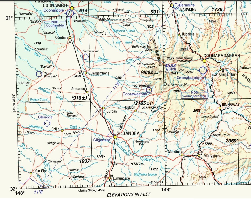
For about $15.00 you can buy pieces of paper that have heaps of waypoints marked on them. You can even draw straight lines between those waypoints to see how far apart they are. You can even use a thing called a protractor to find the direction relative to North that you have to fly to get to the waypoint from where your starting point.

-
 3
3
-
 1
1
-
-
Not if you've got problems with your waterworks.
-
1
-
 2
2
-
-
7 hours ago, Old Koreelah said:
I bet you’ve had too many such tasks, OME.
Fortunately I wasn't actually involved with what the family was doing as I don't know them. I just happened to be around at the time
-
2
-
-
Who would fly IFR below 10,000 in day VMC? One might follow IFR procedures for tracking and reporting in VMC, but that does not preclude flying Quadrantal.
Does anyone not flying IFR go full reporting these days?
-
1 hour ago, facthunter said:
They used to place coloured balls on wires near aerodromes. Perhaps we have become a bit too casual. Nev
The situation here is that it was the pilot's home base, so in a perfect world he should have known the location of the power line. However, this incident occurred closer to the airport buildings, driveway and power lines than it would be normal to be flying, too close to them even when on downwind in a circuit. Unfortunately, this was another example of someone trying to put the wind up someone on the ground by buzzing them.
-
 1
1
-
 1
1
-
 1
1
-
-
That was a very sad local case. The pilot was a mate of the tractor driver, who was slashing the paddock in order to use it for carparking at an airshow. Not only was the tractor driver thee first on scene to see his mate die, but in the process he fell over the paddock fence and wrecked his knee. He is still recovering from that injury. And it wasn't "operations at low level" as in Ag work. It was tomfoolery.
Several months later I was present when the pilot's wife and daughter were at the deceased's hangar to clear out the gear he had there. Not a happy job.
-
2
-
4
-
-
10 hours ago, RossK said:
I'm not sure that's current OME.
I'm pretty sure that you are correct. I could only find diagrams of hemispherical cruise altitudes for VFR. I wonder which mental giant decided to ditch the quadrantals, which clearly would abolish the current problem and improve safety. That quadrantal system worked for years when the volume of traffic must have been less. Now with increased traffic we move to the transgender "See to be Miss..ed".
-
Years ago, wasn't the system quadrantal?
I know that this applies to IFR, but if it's good enough for those conditions, why not for VFR. It's not as though it would incur great disruption to what we have now, and it has the advantage of having pilots using the same system from their very first TIF.
Actually, every one of us now has the opportunity to have a say on this to Government and subsequently to CASA. The Government is calling for submissions into the future of aviation in Australia to 2050. There is a wide range of topics, but safety is one of them. If enough people wrote a short submission just on this topic, it would gain attention. You can read about the White Paper here:
https://www.infrastructure.gov.au/infrastructure-transport-vehicles/aviation/aviation-white-paper
and see the terms of reference here:
-
49 minutes ago, BrendAn said:
delete the thread , i will make a new one
No. Someone will update this one when information becomes available. It's OK!
-
1
-
-
On 22/02/2023 at 1:36 PM, skippydiesel said:
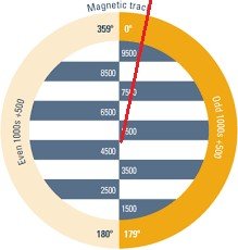
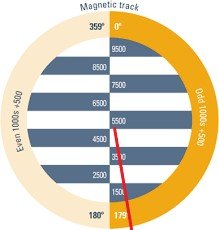
VFR hemispherical cruising altitudes
On 22/02/2023 at 1:38 PM, RossK said:tracking just east of north, 007 at 5500ft, other aircraft was tracking just east of south, probably 170 at 5500.
You have confused me. I'm looking at the VFR levels diagram.
If an aircraft is flying on a magnetic track of 007 its track would be a bit like this:
An aircraft flying on a track of 170, its track would look like this
But by making these diagrams I see your point that these tracks could conflict depending on the relative starting and end points of the respective journeys.
-
BrenDan
You might see that this thread has been reported. Don't worry. I don't know how to alter a thread title, so have sent it to an adjudicator who can alter it to the format approved of for this topic.
Cheers
OME
-
I'd rather climb mons venus
-
2
-
-
Got ya. Too many things whizzing around in my head when I designed it.
How's this for a solution? At the moment the sheet is in portrait orientation. If I switch it to landscape I can add columns for two more sectors, and widen the columns in the top section. That would mean moving the W&B and Pilot's notes sections to the right hand side of the page.
Got to get back to my house renovations. I'll work on it tonight, and put up a revised form for comment.
-
Caveat emptor, quia ignorare non debuit quod jus alienum emit
Let a purchaser beware, for he ought not to be ignorant of the nature of the property which he is buying from another party.
Also, Caveat lector It means that when reading something, the reader should take careful note of the contents, and undertake due diligence on whether the contents are accurate, relevant, reliable
-
9 hours ago, RossK said:
8 legs on your route, only room for 6 on your flight plan sheet
The Event route only has 6 legs - like an insect, not 8 like a spider. Where did you see 8 sectors?
9 hours ago, facthunter said:There's plenty of different ways of doing it and It's illegal to rely on fuel for balance
I copied that from a flying school information booklet. I should have included a row for useable fuel, because that adds to the take off weight, even though the designers might have placed the centre of mass of the fuel so that it had a Moment of zero.
-
It's effectively a lock-out. How can members at Corindi Beach, NSW gather together members from Serpentine WA and Caboolture Qld to attend a general meeting and vote as a block? Technically it is possible, but practically???
-
OK! Another request for your comments. I have created a flight plan form to be used in the Event so that competition entries are all, as the cliches go, on the same page, or singing from the same hymn book.
Your comments on it will be greatly appreciated.
Old Man Emu
-
2 hours ago, skippydiesel said:
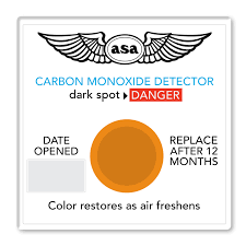
As aircraft pilots, our concern should be about Carbon MONoxide (CO)
Good pick-up! Pays to actually read the letters on the page.
-
Another example of "I'll do the right thing, but I can't stop others being ignorant, entitled dickheads."
On a lengthy leg, usually determined by the time to fly it, I surmise that incorporating readily identifiable features is the way to remain on Track. And it's not usually necessary to overfly a waypoint if your flight plan can indicate a position where you are abeam the waypoint. All you have to do on your WAC is draw a line from the waypoint to your track to intersect at 90 degrees. Admittedly if there isn't a clear line of sight from your track to the waypoint, you might have to dog-leg your track.
-
2
-
-
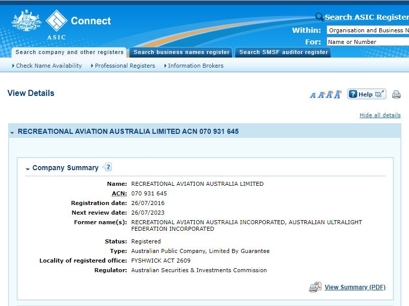
I was implying that by going from an association to a limited liability company, those who were members of the association relinquish control of the operations controlling their interests.
I could be corrected as I have not read RAAus' constitution, so can't comment on member's input into decision-making.
-
1
-
2
-
-
Ahh! The benefits of moving from "Incorporated" to "Limited"
-
2 hours ago, pmccarthy said:
not getting an answer here I looked it up.
Don't you have some sort of carbon dioxide detector in your cabin aircraft? That's what people on this forum would want one for.
Most who do have used these:
At $10 per annum, it would make sense to purchase an electronic device that has a longer serviceable life.
Bunnings has a one for domestic use for $30.00, but pilot supply shops sell ones that you would probably trust a bit more for upwards from $250. I suppose you could do the Sodastream test with the Bunnings one. I don't think that a detector for use as a warning device would need to be accurate to 1 ppm. All you need is to see the output change from normal background level to higher levels. Those ones I've illustated simply change clour - lie X-Ray detector tags medical radiologists wear.
-
1
-
-
43 minutes ago, rgmwa said:
but I live in Perth
Write anyway. Your comments might not apply to Toora, but what about telling of your experiences where Councils did good or bad jobs? You can tell Council what sort of things attract you to an aerodrome for a day flight or en route stop-over. You can tell Council that what you have experienced and would like to see at a WA aerodrome is what east Coasters would like at Toora.
So, please write.
OME

 At $10 per annum, it would make sense to purchase an electronic device that has a longer serviceable life.
Jab down Chinchilla Airport 26/02/23.
in Aircraft Incidents and Accidents
Posted
Notice the bark and stuff on the road on the other side of the truck? Also the port wing has detached and the nose looks moved to port. My opinion is that the plane impacted somewhere left of the picture and began to rotate as it crossed the left side of teh road, still rotating, then the front impacted the roadside bank of the drain. You would need photos from back along that path to confirm Point of Impact and direction of rotation. Doesn't look like it hit a substantial tree.