

old man emu
-
Posts
5,297 -
Joined
-
Last visited
-
Days Won
78
Content Type
Profiles
Forums
Gallery
Downloads
Blogs
Events
Store
Aircraft
Resources
Tutorials
Articles
Classifieds
Movies
Books
Community Map
Quizzes
Videos Directory
Posts posted by old man emu
-
-
3 hours ago, farri said:
it looks like a stall, spin, into the ground, from a low-level turn,
I like that opinion. The damage supports it. As does the ejection through the windscreen.
-
 1
1
-
-
A bloke up in Chinchilla might have one.

-
 1
1
-
-
Who said the airplane was EXPERIMENTAL? I can clearly see "VH-" on the fuselage. Unless someone knows the airplane from Serpentine in WA.
3 hours ago, RFguy said:The manslaughter wont get up. it wasnt charter, pax tasks own risk in light airplane.
Sorry, you are wrong. It doesn't matter if it was charter, RPT or private. The onus is on the operator of a vehicle (in this case and airplane) to ensure it is safe for use. If the pilot was the owner, then it is his responsibility to ensure the vehicle is maintained to the expected levels of safety. If CASA has gone him for being unlicensed, to me that means he never was issued with a licence. I was issued with a licence way back when, and it is still live, but it would be foolish of me even to undertake a solo flight right now as I'm way, way out of currency. In CASA's eyes, being unlicensed means never having passed a theory and practical examinations.
There's been lots of discussion about pilots failing to make broadcasts in the vicinity of aerodromes. Ever thought it might be because the pilots are not licensed and are trying to avoid detection?
-
 2
2
-
 1
1
-
-
1 hour ago, facthunter said:
How Nice. and it's a Law of strict liability. Why does anyone fly Here? Nev
It's to express the bushranger spirit by flaunting the Law!
-
1
-
-
If you really want to travel with a group of like-minded individuals you must in the first instance obtain the approval of SHMBO.
-
A Search Warrant can be issued to a CASA investigator by virtue of the Civil Aviation Act 1988, Part IIIA Division 2 Paragraph 32 (AF)
-
1
-
-
Better than being labelled "Leader of the Pack"
-
Let's keep an eye on this one. However, I don't see much more of it appearing in the Court List for a few months, and any Trial won't be unit at least this time next year.
Just to answer the question, "Why manslaughter? " The elements of manslaughter in Queensland are: (1) the deceased is dead; (2) the defendant caused the deceased's death; (3) the defendant did so unlawfully, ie any defences are excluded beyond a reasonable doubt.
The unlawful acts would relate to licensing and maintenance, and since those matters are of the "strict liability" type, a finding of guilt can be the only outcome.
-
1 hour ago, Garfly said:
But the OP's question was not about having the max fun from flying but how to efficiently complete an ASA/NAIPS flight plan when the necessary waypoint designators were hard to find.
I reckon that has been answered OK and I hope the answer helped. However, we must maintain the culture of this forum an generate more thread drift than a Paddle-Pop stick in a drain after a summer torrential downpour.
1 hour ago, Garfly said:the anxiety around getting lost has also gone,
The anxiety of getting lost is dependant on the distance from your last accurately confirmed location. Do people simply plan to fly long legs from D to P, or do they insert F, J, and L on their flight plan as places merely to be noted in order to confirm Track Made Good?
All this denigration of map reading is making me think that a major Search and Rescue operation will be the finale to Winging it Down the Castlereagh. At worst, the flight can be done IFR&R&R from Tooraweenah to Coonamble. The test I have included is getting from Coonamble to Tooraweenah via the designated locations.
IFR&R&R: I follow roads, railways and rivers.
-
8 hours ago, Garfly said:
OME, if you'd shout yourself one of those newfangled EFBs, every aeronautical chart for the whole country would be at your fingertips. And they'd be current.
That is quite true, and I'm not such a Luddite as to refuse to use these devices. They would not have been invented if they were not convenient to use. The point I am making is that, to my way of thinking, preparing a flight plan with basic tools is part of the enjoyment of recreational flying. Also, if navigating by EFB is so fantastic, why does CASA require the carriage of relevant, current WACs for the proposed flight, and also a compass and clock?
When a pilot relies on an EFB, the EFB becomes part of the aeroplane's essential equipment for that flight. If another essential piece of equipment failed, would a wise pilot continue the flight, or put down as soon as practicable to rectify the problem?
-
A 5-point harness is, indeed, the best restraint system, but the next best is the over-shoulder/waist system. Then there is the lap/sash system with inertia locking, and finally the lap only system. The use of these is a compromise between restraint and freedom of movement. Available attachment points create another factor in the choice. The result is a compromise, in which the lap/sash wins out.
The purpose of a restraint system in an aeroplane used for A to B transport is to prevent the upper body rotating forward when the impact forces act parallel, or within about 10 degrees of the longitudinal axis of the aircraft, and similarly for the lateral axis. If the forces act at a much greater from the longitudinal axis, rotation around the vertical axis occurs. If a lap/sash restraint is used, and the force comes at an angle to the side of the body opposite to the shoulder that the sash runs over, then the body can rotate under and out of the sash.
If the impact forces act from below the longitudinal axis, that would induce rotation around the lateral axis. Usually those forces come from the front. In that case the body can slide under and out of the lap belt.
-
I doubt that it would be economical. I'd scrap it and sell off the instruments. I would not bother with the engine - a total strip down/rebuild would be more than buying one off the shelf. I can't see any other parts having much value as replacements.
-
1
-
-
1 minute ago, skippydiesel said:
unless I am required to be at a certain point in space
That's probably the crux of safety in busy areas. If everyone uses the same locations when, say approaching an aerodrome, then traffic flow is more orderly and the risk of collision is reduced.
-
I wonder if the dismantling we often see when Jabirus prang is actually a designed passive safety device like crumple zones in cars. By breaking off wings and rear fuselage, a lot of the pre-impact kinetic energy of the aircraft is dissipated, reducing the amount to be dissipated by the cockpit area.
-
2
-
-
3 hours ago, KRviator said:
Sounds like they're short-changing you on the theory component somewhat
That's my impression, too. My next question is: How old is your instructor? A twenty-something instructor has grown up using digital devices that do all the calculations without the operator really understanding how those calculations are done.
This reliance on digital devices resulting in the loss of basic knowledge was the basis of the 1958 short story by Isaac Asimov, entitled "The Feeling of Power". The plot like goes like this: In the distant future, humans live in a computer-aided society and have forgotten the fundamentals of mathematics, including even the rudimentary skill of counting. A technician, discovers how to reverse-engineer the principles of pencil-and-paper arithmetic by studying the workings of ancient computers which were programmed by human beings. The rest of the story line follows the usual "military takes something unwarlike and turn it into a weapon system" scenario. But that is not the point I am making. My point is that over reliance on tools without having the fundamentals of what the tool does, can have negative effects.
-
1
-
-
Post model details and we can search it Interwebby.
Except this might stump you:
It’s not only a battery replacement.
The battery alone cannot just be purchased. You need to have the tools, hardware and software to perform a battery replacement.
Full functional testing is done on the unit after the battery is replaced, to ensure the unit will last another 5 years in the field. The battery of a Personal Locator Beacon needs to be replaced by a trained technician. (https://www.redbaronalse.com.au/product/acr-plb-resqlink-battery-replacement/ )
-
1
-
-
QANTAS is changing its logo from The Flying Kangaroo to The Returning Boomerang.
-
1
-
1
-
-
1 hour ago, hkaneshiro said:
YPJT - BODD (Boddington mine). I knew there was BODD waypoint - but didn't see it marked on the VTC/VNC and was wondering how people knew about it...
You have to use primary information sources. For a pilot/navigator, if no VTC/VNC , go to the WAC for the area where you are operating . Boddington Mine is a bloody great hole in the ground. I dont have the relevant WAC, but I be it's marked on in, especially if it's a waypoint. If you want to find its Lat/Long to put into your SmartNav, use the technique I explained in an earlier post. Since I don't have the relevant WAC, I simply went to Google Maps and found that Boddington Mine is located at -32.764317, 116.360615. Then I plugged those numbers into fhttps://www.gps-coordinates.net/gps-coordinates-converter and got -324044, 1163112, which is as accurate as ERSA location details are.
Your questions, which are not in any way dumb, make me wonder if you have ever used a WAC, or do you simply carry the necessary ones for your flight in case a CASA Inspector pounces on you for a ramp check?
-
That's the second impact we have discussed recently (Coonabarabran was the other) where the pilot's restraint was not being used as designed. Maybe there's a need for a "Harnesses Save Lives" campaign.
-
1
-
-
It might seem like I am dumping of those of you who rely heavily on electronic devices for flight planning and execution. I can see the usefulness of these tools as a quick reference source of navigational information whilst in flight. That is the product of the advances in digital technology over the past 50 years. But an EFB is merely a tool. What I infer from some of the posts here is a lack of knowledge of basic principles of navigation.
When I was 5-years old, people began to teach me how to use a tool to communicate. The tool was called a "pencil". As I grew older I was taught to use another communication tool, an ink pen. Once I had learned not to blot my copybook, I was allowed to used another type of tool, a ball point pen, known by the trade name "Biro". These tools served me well through my Primary, Secondary and Tertiary education years. Later, I was taught to use another tool, a manual typewriter, which led me to the computer keyboard (whose complete bag of tricks I have yet to explore). Nowadays, I mainly use the computer keyboard to communicate. And right now I am looking at tools that will allow me to record an the sound of an interview digitally, then use some software to convert via my computer the sound to the symbols we call words. That tool will be a boon for my history research.
However, while I have these wonderful new tools with which to make written records events or facts, I still know how to do the same thing with a pencil - or even a stick on dirt if that is appropriate. So while I have apparently been making disparaging remarks about electronic devices for navigation, my point is that before using them, one must have the knowledge and experience of using the "primitive" tools from which the electronic devices have evolved.
-
1
-
-
1 hour ago, Student Pilot said:
Give it 20 years, it will be built out and people complaining about aircraft.
Won't take that long to be built out. The rate of housing estate development in that part of Sydney makes the popping up of mushrooms after rain look glacial. But that depends on the Government stating up to Big Business. Here is the map indicating the impact of the NASF noise contours (blue line) compared to the existing ANEF controls (orange line) for Nancy Bird Walton Airport:

A new clause has been inserted in the final District Plans that could have the effect of stopping thousands of new homes around the Western Sydney airport, says the Urban Taskforce. "The draft Western City District Plan made no reference to the National Airports Safeguarding Framework (NASF) that defines excessive new noise contours around airports but a new clause has appeared in the recently released final plans that could have dramatic impacts on new housing up to 25 km from the Western Sydney airport,” says Urban Taskforce CEO Chris Johnson “The new clauses is 28k on page 70 in the Western District City Plan and it requires ‘giving effect to the National Airports Safeguarding Framework, incorporating noise…measures’. This introduces a new method for measuring noise that could stop new housing that is currently permissible, across an extra 240 square kilometres around Western Sydney Airport.”
The Urban Taskforce calls on the NSW Government to remove references to the NASF system in relation to noise from its Western City District Plan to ensure that there is no confusion over where housing can be located around the Western Sydney Airport. The Urban Taskforce calls on the NSW Government to remove the requirements to give effect to the NASF system in relation to noise from all District Plans and to continue to only utilise the long term and respected ANEF system for land use planning.
The Urban Taskforce Executive Committee is elected by the members and oversees corporate policy, governance and financial management of the Urban Taskforce Australia. It includes some of Australia’s leading property developers. The Executive Committee members are:
Peter Spira AM
(Chairman) – Urban Taskforce AustraliaDavid Tanevski
(Hon.Secretary/Treasurer) – Managing Director, KWC Capital PartnersAllen Linz
(Deputy Chairman) – Managing Director, Rebel Property GroupDavid Ghannoum
(Deputy Chairman) – Regional Managing Director, MultiplexLang Walker AO
Founder & Executive Chairman, Walker CorporationRichard Scheinberg AM
Director, McDonald IndustriesJohn Carfi
Chief Executive Officer, AqualandMatthew Lennartz
Executive Manager, Planning & Government, MeritonKevin Nassif
Chief Operating Officer & Director, Holdmark Property GroupLink to full article: https://www.urbantaskforce.com.au/new-clause-in-district-plans-could-stop-housing-in-an-extra-240-square-kilometres-around-western-sydney-airport/
-
1
-
-
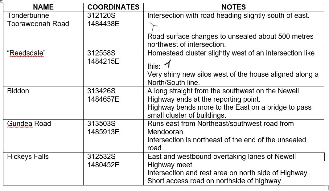
See those numbers with the little circle beside them? They are degrees of latitude and longitude, in a grid system. You count down from the top to the location, eg Collie, and that will give you what are called "Northings". Then you do the same thing from left to right. That will give you what is called an "Easting" You enter those grid coordinated in your flight planning gizmo, but for flights in Australia the Northing is entered as a negative number because we are below the Equator (0 degrees). Eastings in Australia are alway a positive number.
See if you can find these locations on the map I posted.
You can check yours answers on Google Maps if you centre on this location: 111 Tooraweenah Aerodrome Rd, Tooraweenah.
-
1 hour ago, 440032 said:
Another flux capacitor failure?
No. In=depth investigation by expert investigators from our very own ATSB have show positively, and with diagrams and complex computer simulations, that the unplanned impact with the Earth, as opposed to a planned impact (otherwise known as greasing it on), was the result of the aircraft's discombobulator discombobulating at a critical flight phase.
A Senior Spokesperson for the ATSB hinted that the ATSB's work result will be published for peer review in a coming issue of Amazing Stories.
-
1
-
-
A waypoint is a specified geographical location used to define an area navigation route or the flight path of an aircraft employing area navigation.
Specified by whom?
On my piece of paper, I can specify any geographical location to use in my flight plan.
On 22/02/2023 at 4:05 PM, hkaneshiro said:if i am planning a flight in an unfamiliar area, how would I know if there is/was a VFR waypoint somewhere to notify Airservices of my flight plan
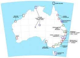
Here are the areas covered by VTCs in Australia
and here are the VNCs Lots of blank spaces for you to fill with your personally specified waypoints.


 and here are the VNCs
  Lots of blank spaces for you to fill with your personally specified waypoints.
Light plane crash at Ball Bay, north of Mackay Qld 24/12/2021
in Aircraft Incidents and Accidents
Posted
I see no difference in my Duty of Care to a passenger, or other people in the vicinity, if I was driving a ground vehicle, navigating a boat or flying an aircraft. That is what is the crux of any offence resulting an any degree of harm to another person, ranging from a simple slap on the face to murder. It is simply that the Law has set a scale based on the degree of harm and the circumstances leading to the infliction of that harm.
That is the basis of 'contributory negligence'. Contributory negligence occurs when the injured person themselves is found to have contributed to the cause of their loss or injury. If an applicant has failed to take reasonable care for their own safety or loss then they will be found contributorily negligent. But that only applies in Civil litigation. In Criminal litigation, the onus is always on the actions or inactions of the accused.