Moneybox Posted June 19, 2025 Posted June 19, 2025 Does OzRunways list R.F.D.S. airstrips? If you ever get the chance to navigate your way across this big wide country of ours you might find it useful to have a few extra airstrips recorded just incase you need an unscheduled stop. This might be particularly useful to those navigating IFR. Each time I came across one of these I checked OzRunways but they didn't show up. Perhaps it's just the options I have set. In any case I've recorded the coordinates of each one I came across between SA and home in WA. 1
onetrack Posted June 19, 2025 Posted June 19, 2025 (edited) Yes, several locations on major highways in Western Australia, in particular, are specially widened and painted with piano keys to facilitate the landing of RFDS aircraft for highway crash emergencies, and other local medical emergencies. The reason they do not appear on OzRunways is because traffic control must be formerly initiated with the Police or Main Roads W.A. staff, before they can be used as airstrips. The highway is effectively and officially closed to traffic for the duration of RFDS aircraft use. See 6.4.1 "Traffic Management Plan" below. As all major W.A. highways permit the use of triple road trains running to 120 tonnes gross (and oversize loads to considerably larger levels, up to 300 tonnes and occasionally even higher) - and that the frequency of road trains in rural and remote locations is at a considerable level (I've come across 8 double road trains in a row, on a rural highway. They are obliged to stay 200M apart) - then you can imagine that the authorities don't want to see serious interaction between the likes of a large road train and an aircraft, thus the reason for intensive traffic management when aircraft traffic and road traffic are likely to come into conflict. https://www.mainroads.wa.gov.au/49c4d6/globalassets/technical-commercial/technical-library/road-and-traffic-engineering/guide-to-road-design/additional-road-design/emergency-landing-strips/emergency-landing-strips-policy-and-application-guidelines.pdf Main Roads W.A. actually provide instructions on the construction of airstrips on the major highways under MRWA control. https://www.mainroads.wa.gov.au/globalassets/technical-commercial/technical-library/guideline-drawings/emergency-runway-strip-details/200431-0003-emergency-runway-strip-details.pdf Edited June 19, 2025 by onetrack 1 2
Red Posted June 19, 2025 Posted June 19, 2025 What an excellent undertaking. Kudos to whoever pushed to get this done Not many countries it could work 1 2
RossK Posted June 20, 2025 Posted June 20, 2025 7 hours ago, Red said: What an excellent undertaking. Kudos to whoever pushed to get this done Not many countries it could work RFDS Training PC-24 1 1
facthunter Posted June 20, 2025 Posted June 20, 2025 Sweden did it long ago for the SAAB Viggen, I think it was.. Nev 3 1
onetrack Posted June 20, 2025 Posted June 20, 2025 (edited) It's amazing to see the wingspan of the PC-24 in relation to the highway reserve width. Even with the additional width of sealed highway edges, there's not a huge margin for drift error in the event of a strong crosswind. One of my former business partners owned a Piper Cherokee, and about 1985/86, he took a young girl for a joyflight, departing Kalgoorlie to the West. Not long after becoming airborne, the engine stopped due to fuel starvation. He put the Cherokee down on the (recently-widened, fortunately) highway between Kalgoorlie and Coolgardie. All went well, avoiding the low level of traffic, until the middle of the rollout, when a large roadside sign loomed up! The roadside sign was well built with dual heavy pipe uprights, and he had no chance of avoiding it due to inadequate control surface authority at low speed, and he clobbered the sign with a wing, doing major structural damage to the aircraft. No-one was hurt. He claimed to me in later discussion that the crossover fuel tank selector valve failed. Knowing him and his generally erratic style, I suspect he was lax when it came to correctly setting the fuel tank valve, and inadvertently shut off the fuel supply. Edited June 20, 2025 by onetrack
facthunter Posted June 20, 2025 Posted June 20, 2025 Keeping near the Runway centre is Often a challenge. Trees and shrubs and posts can bother the wings. With a road there's no other runway available. IF the Crosswinds limiting you need to have an alternate. Nev 1
Red Posted June 20, 2025 Posted June 20, 2025 (edited) 3 hours ago, facthunter said: Sweden did it long ago for the SAAB Viggen, I think it was.. Nev Thy still do, but its a very different operation and obviously not available to civilian aviation .....Well apart from being chosen in an emergency of course like anywhere else Edited June 20, 2025 by Red 1
facthunter Posted June 20, 2025 Posted June 20, 2025 Watch for wires, poles trees, cattle grids, vehicles and sensational headlines when landing on a road. Nice to be near one when landing other places. Nev 1
BrendAn Posted June 20, 2025 Posted June 20, 2025 19 hours ago, Moneybox said: Does OzRunways list R.F.D.S. airstrips? If you ever get the chance to navigate your way across this big wide country of ours you might find it useful to have a few extra airstrips recorded just incase you need an unscheduled stop. This might be particularly useful to those navigating IFR. Each time I came across one of these I checked OzRunways but they didn't show up. Perhaps it's just the options I have set. In any case I've recorded the coordinates of each one I came across between SA and home in WA. raaus type aircraft have a runway that stretches from northam to port augusta if you fly ifr. 2 1
facthunter Posted June 20, 2025 Posted June 20, 2025 (edited) You don't need a long runway flying RAAus types. That's one factor making them acceptably safe. The landing place doesn't have to be straight either. Nev Edited June 20, 2025 by facthunter 2 1
BrendAn Posted June 20, 2025 Posted June 20, 2025 21 hours ago, Moneybox said: Does OzRunways list R.F.D.S. airstrips? If you ever get the chance to navigate your way across this big wide country of ours you might find it useful to have a few extra airstrips recorded just incase you need an unscheduled stop. This might be particularly useful to those navigating IFR. Each time I came across one of these I checked OzRunways but they didn't show up. Perhaps it's just the options I have set. In any case I've recorded the coordinates of each one I came across between SA and home in WA. How are you going with your RPC
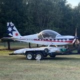
Moneybox Posted June 20, 2025 Author Posted June 20, 2025 1 hour ago, BrendAn said: How are you going with your RPC Great if I was not spending weeks prospecting, then tripping to China, then a quick trip to Melbourne and Adelaide (7000km in 8 days by road towing), then a quick trip to Geraldton and back. Now I'm rebuilding the car trailer that I brought the plane home on so that it can handle the new Bobcat and a quad bike. That gold was for three and a half weeks so Mrs M wants to go straight back. I'm hoping by the time we're ready I have a POW (program of works) in place so we can operate Bob, the new Bobcat. Then I might get a chance to get back into the plane 😳. I desperately need to be able to fly. 1 1
Moneybox Posted June 20, 2025 Author Posted June 20, 2025 (edited) R.F.D.S. emergency air strips east to west... There may have been more if I was having a micro sleep as I passed by... Edited June 20, 2025 by Moneybox 2
onetrack Posted June 20, 2025 Posted June 20, 2025 They are all named for convenience and reference purposes. The first one in MB's list is called Chadwick Roadstrip. https://www.google.com/maps/place/Chadwick+Roadstrip/@-31.5739973,130.1602548 1
Moneybox Posted October 19, 2025 Author Posted October 19, 2025 How often do you NOT find an airstrip that is listed in OzRunways? On our way home from our African holiday we looked at the weather forecast for cue, it was 40°C in Cue on Friday, a sign of things to come in the next few months so we decided to take a look at options to live further south. Our main reason to be in Cue is for the gold prospecting but if I'm up flying soon that'll take priority and Cue is not the best location to fly in the heat of summer. We started looking at Northam where the plane is chained to the ground. Anything with a bit of dirt around it was over $1,000,000 or falling apart so we checked nearby towns. We viewed houses in Toodyay and York before finding a high set 10 acre stony block within walking distance of OZYOK. That's the shire airstrip 1200m of grass and no fees. No fuel either but YWGM has Mogas 98 just a few miles east. Before blowing the kid's inheritance (they'll never get any anyway by the time I'm done) we should slip down and take a look at the airstrip. Well I dare say the airstrip is simply not there. We drove down the winding track shown on OzRunways surrounded by 1m high Canola to find the entire area ahead just more Canola. The airstrip must be plowed under and planted along with the rest of the paddock. We should be home later tomorrow so I'll call the shire of York and make some inquiries meanwhile my money is still safe in the bank. 4 1
Thruster88 Posted October 19, 2025 Posted October 19, 2025 The strip was most likely hosted by a farmer, land owner. Land my have been sold or situaton has changed. My friend has a similar set up in central West NSW, they own the land but the local council is the operator. 2 1
skippydiesel Posted October 19, 2025 Posted October 19, 2025 "Cue is not the best location to fly in the heat of summer." Much the same in most areas of Au . You need a strategy - TO at dawn, climb to cooler altitudes. On those few occasion, every summer, that the flying itch must be attended to, I find that dawn/first light departure (watch for grazing critters) usually allows for a mid morning landing somewhere(?), before returning to base before mid day. Works for me but I no longer rise from my pit as sprightly as I may have done 20 years ago😈 2
Recommended Posts
Create an account or sign in to comment
You need to be a member in order to leave a comment
Create an account
Sign up for a new account in our community. It's easy!
Register a new accountSign in
Already have an account? Sign in here.
Sign In Now